1. From 1880-81 Survey of India report
A detail survey on the scale of 1 inch equal to 1 mile was extended over the country in the immediate vicinity of Kotra and between Oodeypore and Sirohi, represented on the index maps by Sheets 85, 86 and 89. It included portions of the States of Mewar, Sirohi and Idar.
The Cantonment of Kotra was surveyed on a scale of 8 inches equal to 1 mile. This survey covered an area of 3.03 square miles and will furnish a map in one sheet.
General Report on the Operations of the Survey of India, Office of the Superintendent of Government Printing, Calcutta, 1882, p 10 . Link.
Sunday, February 19, 2017
Political Administration
Mewar
"Meywar, perhaps the eldest of the Rajput States..."
Rajputana Gazeteer, Volume III, Government Central Branch Press, Simla, 1880, p 3.
Jura
The 1880 Rajputana Gazeteer states that the estimated revenue of the Rao at Jura was Rs. 6,000 while the amount of tribute paid by the Rao was Rs. 600.
Rajputana Gazeteer, Volume III, Government Central Branch Press, Simla, 1880, p 62-63.
In 1908-1909, the revenue of the Rao of Jura was estimated to be Udaipuri Rupees 13, 670 and tribute to the Mewar Durbar of Udaipur Rs. 600. A
___ (1909). Administration Report of the Mewar State for the Year 1908-1909. Scottish Mission Industries Co., Ltd., 1909. p. 43. Link.
This website claims that Juda (one of the major villages in Kotra) was one of the thikanas of Mewar (even issued its own revenue stamps). The Chauhans of Juda were what the wikipedia page of Mewar calls "bhomiya sardars" of Mewar. It seems the bhomiya sardars are the lowermost category of jagirdars (big landowners).
Hilly Tracts
The whole of the mountainous country to the west of Meywar, from the borders of Dungarput on the south to the confines of Sirohi and Marwar on the north, is politically known as the Hilly Tracts of Meywar.
Rajputana Gazeteer, Volume III, Government Central Branch Press, Simla, 1880, p 4.
Bhumia chiefs of Hilly Tracts divided into 'Kherwara group' (Jawas, Para, Madri, Chani and Thana) and 'Kotra group' (Jura, Oghna, and Panarwa).
Walter, KM. (1882). Report of The Political Administration of The Rajputana States for 1881-1882. p.86-87. Link.
The Hilly Tracts of Meywar comprise that part of the country lying to the west and south of Udaipur, up to the borders of the states of Serohi, Mahi Rauta, and Dungarpur, between the 24th and 25th degrees of north latitude and 73rd and 75th degrees of east latitude.
Showers, H. L. (1891). The Meywar Bhil Corps. The Journal of the United Service Institution of India, XX (84). 87. Link.
Kotra Bhomat
In 1909, the Kotra bhomat consisted of 3 estates "ruled by Bhumia chiefs": Jura, Panarwa, and Oghna. At that time, Kotra had not been settled; land revenue was collected at the rate of one-fourth of the crops.
___ (1909). Administration Report of the Mewar State for the Year 1908-1909. Scottish Mission Industries Co., Ltd., 1909. p. 43. Link.
After reorganization of districts in 1940, "the Bhomat lies in the modern district known as Kherwara." As of 1942, the Bhomat had 690 villages, of which 36 were khalsa, 652 were jagir, and 2 were muafi. This document claims that the name Bhomat is based on a misconception; the prevailing tenure in the Bhomat is really jagir not bhum.
___ (1944). Report on the Administration of Mewar State for Years 1940, 1941 and 1942. Madras: The Madras Law Journal Press. P. 37-38. Link.
"The population [of the Bhomat] was turbulent and handed over to the British Administration in 1838 and brought again under Mewar State in 1930.
___ (1944). Report on the Administration of Mewar State for Years 1940, 1941 and 1942. Madras: The Madras Law Journal Press. P. 38-39. Link.
Powers of Hilly Tracts' Chiefs
The chiefs themselves are said to derive little benefit from [the produce of the land], their share of the revenue or produce being very much in the proportion to tho power they possess of exacting them from their subjects, the more powerful of whom have been in the habit of giving what they do, more as a benefaction to the chiefs, than from any acknowledged or inherent right on their part to enforce it.
Hunter, W. (1846). Report on Some of the Rights, Privileges, and Usages of the Hill Population in Meywar. Journal of the Royal Asiatic Society of Great Britain and Ireland, 8, 176-192. Link.
Boundary Dispute
It was reported that, in 1908-1909, "the appeal in the long-standing boundary case of Khara-kutra-Maria was heard by Colonel C. Hutton Dawson (Political Superintendent, Hilly Tracts) and Lieutenant-Colonel H.D. Merewether (Political Agent, Mahi Kantha), and the disputed ground was decided to belong to Jura (Mewar)."
Administration Report of the Mewar State for the Year 1908-1909, Scottish Mission Industries Co., Ltd., 1909, p. 43. Link.
Political Subdvisions
During Pratap's reign, his younger brother Jagmal appealed to Akbar upon being rejected by the chiefs as his father's heir. Akbar bestowed upon him the pargana of Jahazpur (in Mewar).
Ramya Sreenivasan, The Many Lives of a Rajput Queen: Heroic Pasts in India C. 1500-1900, University of Washington Press, Seattle, 2007, p. 74 (Link)
As of the 1901 census, the State was divided into the following administrative units.

Erkine, K.D. (1908). A Gazetteer of the Udaipur State with a Chapter on The Bhils and Some Statistical Tables. Ajmer: Scottish Mission Industries, Co., Ltd. p.14. [Preface: "This book is merely a collection of such portions of Vols. II-A and II-B of the series of Rajputana Gazetteers...The chapter on the Bhils has been added because it may be of interest and because these people are numerous here."]
"A hakim is in charge of each of the eleven zilas and six parganas into which Mewar is divided. Each zila is composed of two or more subdivisions with a naib-hakim in charge of each, but, with one exception (Kumbhalgarh), there is no such official in a pargana."
Imperial Gazetteer of India, v. XXIV, Oxford at the Clarendon Press, 1908, p. 98. (Link)
In 1940, Mewar districts were reorganized. The number of districts at the time, 17, was considered excessive for the area of Mewar. Consequently, the number was reduced from 17 to 8. At that point, the district administrators - hakims - were replaced by deputy collectors. The 8 new districts were:
- Girwa
- Kherwara
- Sarara or Magra
- Rajsamand
- Kapasin
- Bhilwara
- Chitor
- Jahazpur
___ (1944). Report on the Administration of Mewar State for Years 1940, 1941 and 1942. Madras: The Madras Law Journal Press. P. 7. Link.
As of 1942, there were 456 jagirs of which 23 were ranked in the first class (solah or Umrao), 33 in the second class (battis) and the rest in lower classes (gole).
___ (1944). Report on the Administration of Mewar State for Years 1940, 1941 and 1942. Madras: The Madras Law Journal Press. P. 13. Link.
As of 1942, the total number of villages in Mewar State was 5,563 of which 1,604 were Khalsa villages.
___ (1944). Report on the Administration of Mewar State for Years 1940, 1941 and 1942. Madras: The Madras Law Journal Press. P. 20. Link.
During settlement, which according to this document started in 1922 (earlier according to other sources), several forms were tenure were acknowledged. These are described in detail.
___ (1944). Report on the Administration of Mewar State for Years 1940, 1941 and 1942. Madras: The Madras Law Journal Press. P. 25-26. Link.
Settlement
The first settlement in Mewar State occurred in 1879 (by A. Wingate), but settlement of Kotra was not completed until 1955, when 304 villages were settled.
Agarwal, B.D. (1979). Rajasthan District Gazetteers: Udaipur. Jaipur: Government of Rajasthan. p. 338-340.
Allegiance
"The hill districts of Udaipur to the south and south-west are inhabited by wild and restless tribes of Bhils and Girasias, under Rajput Chiefs owing a nominal allegiance to Udaipur, holding rights of property in the land over which the Maharana has no power, and levying blackmail on neighbouring villages and a tax on the passage of goods and travellers, for whose safety they are considered responsible."
C. U. Aitchison (Compiler), Treaties, Engagements, and Sanads Relating to India and Neighboring Countries, Vol III, p. 14, Superintendent Government Printing, Calcutta, 1909. (Link)
Bhumia Tenure
The Bhumia, the holder of this tenure, "had a proprietorship very different than feudal chiefs or tenants of crown lands. Originally, they seem to have belonged to the aristocrat class, but gradually sank from that position to that which they now occupy, which is, however, one of respectability and of considerable independence."
Sherring, M., The Tribes and Castes of Rajasthan, Cosmo Publications, New Delhi, 1975, p. 9. Link.
Independence of Bhomat chiefs
"None of the Grasia chiefs were ever subjugated by Meywar, and they hold the bhum, or right of property in the land, over which the Rana has no power. They are not liable to be called upon for regular service, to which they are not subject, or to attend at the capital; but they pay a quit-rent in token of submission."
Rajputana Gazeteer, Volume III, Government Central Branch Press, Simla, 1880, p 62-63.
Around 1826, the British political agent in Mewar conducted an inquiry to determine whether any precedent existed for the chiefs of Jura, Merpur, Ogana and Panarwa to pay tribute to the Mewar Durban. It was determined that even if the Mewar Darbar ever had a valid claim of supremacy over these chiefs, it had been dormant for at least a period of 40 years.
Hunter, W. (1843), Art. IX - Report on the Rights, Privileges, and Usages of the Hill Population of Meywar. Journal of the Royal Asiatic Society of Great Britain and Ireland, Vol. 8, p. 176. Retrieved from link. (Captain W. Hunter of the Mewar Bhil Corps)
The plains and foothills of Mewar "were decisively mastered by the Rajputs. The Bhomat, however, presents a completely different picture. There the Bhils were never conquered; even the Jagirdars are of Bhil ancestry."
Carstairs, G. Morris (1955), Bhil Villages of Western Udaipur: A Study in Resistance to Social Change, India's Villages. Bombay: Asia Publishing House. p. 68. Link.
Economy and Amenities
1. Report on agriculture in the Kotra area from 1880-81
The country is naturally not highly cultivated, still a considerable amount of wheat is grown in the cold weather; and in one valley, where there happened to be several villages inhabited by Brahmins, I saw the finest wheat I think I have ever seen in India. The cold weather crops are nearly always irrigated by small canals from the streams. The Bhils are decidedly skillful in laying out and making small irrigation channels.
I saw one or two fields of opium, but the results were very bad; the soil is evidently unsuitable. Turmeric, ginger, chilly, and yam are grown in several places. During the rains, Indian-corn and bajra are extensively cultivated and form the principal food of the country. Hill sides are cleared of jungle with immense labor during the cold weather; the trees are allowed to dry where they fall, and the whole is then fired and the seed is dropped among the ashes.
General Report on the Operations of the Survey of India, Office of the Superintendent of Government Printing, Calcutta, 1882, Appendix 'Extracts from The Narrative Reports of the Executive Officers', p 12 . Link.
2. Industry
Zenith Steel Pipes submitted an application to set up a cement plant in Kotra in 1980.
India. Parliament. Rajya Sabha., . (1952). Parliamentary debates: official report. New Delhi: Council of States Secretariat, Appendix CXVI, p 163. Available at https://catalog.hathitrust.org/Record/000053704
3. Roads
Status of Roads from 1880-81 survey
It may be said that roads do not exist; the best is that from Kherwara through Kotra to Rohera (Rohida in present day Sirohi district) but even this road is so small and ill-defined that a guide is necessary, or a stranger will infallibly lose his way. In such a country, carts do not exist' bullocks and donkeys are the only beasts of burden even met, although I have more than once seen large herds of breeding camels belonging to the Mayarana of Oodeypore (Udaipur) grazing in large valleys.
General Report on the Operations of the Survey of India, Office of the Superintendent of Government Printing, Calcutta, 1882, Appendix 'Extracts from The Narrative Reports of the Executive Officers', p 11 . Link.
Kotra-Rohera Road mentioned from 1881-82
Construction of road between Kotra and Rohera began in 1881-82. The road will pass for 18 or 20 miles through Jura, the remaining 16 or 17 miles in Sirohi territory. The road will terminate on the top of Kappa Pass, and it is hoped that the Sirohee Darbar will construct the remaining 3-4 miles.
___, Report of The Political Administration of The Rajputana States for 1881-1882, date unknown, p.110. Link.
Kotra-Kherwara Road Mentioned in 1906
A list of roads in erstwhile Udaipur State from 1906 states that an unmetalled road, 48 miles long, exists between Kotra and Kherwara. The current distance between Kotra and Kherwara, as per Google Maps, is 88 kilometres (54 miles). Thus, it is possible that the same unmetalled road of 1906 was since improved upon.
Erskine, Keith David, 1863-1914, and C. C. (Charles Cuningham) Watson. Rajputana Gazetteers. Ajmer: Scottish Mission Industries, 19041909, p 18. Available at https://catalog.hathitrust.org/Record/012155477/Home.
4. Post office
A post office was reported in Kotra as early as 1906.
Erskine, Keith David, 1863-1914, and C. C. (Charles Cuningham) Watson. Rajputana Gazetteers. Ajmer: Scottish Mission Industries, 19041909, p 19. Available at https://catalog.hathitrust.org/Record/012155477/Home.
5. School
A "lower primary" school, run by the Mewar Bhil Corps, was reported in Kotra in 1906. It was attended by 13 students.
Erskine, Keith David, 1863-1914, and C. C. (Charles Cuningham) Watson. Rajputana Gazetteers. Ajmer: Scottish Mission Industries, 19041909, p 23. Available at https://catalog.hathitrust.org/Record/012155477/Home.
6. Hospital
In 1905, there was reported to be two hospitals in Kotra. One was a civil hospital, the other a "detachment hospital" (presumably associated with the Mewar Bhil Corps. They had a capacity of 8 and 7 beds respectively, and were both maintained by the government.
Erskine, Keith David, 1863-1914, and C. C. (Charles Cuningham) Watson. Rajputana Gazetteers. Ajmer: Scottish Mission Industries, 19041909, p 23. Available at https://catalog.hathitrust.org/Record/012155477/Home.
Friday, February 17, 2017
Human Geography
Population
In 1906, the Kotra bhumat was reported to have a population of 17,641, including 903 persons classified as "urban" (presumably living in Kotra cantonment?).
Erskine, Keith David, 1863-1914, and C. C. (Charles Cuningham) Watson. Rajputana Gazetteers. Ajmer: Scottish Mission Industries, 19041909, p 14. Available at https://catalog.hathitrust.org/Record/012155477/Home.
In 1922, the population of Kotra cantonment was reported to be 857.
India Census Commissioner (1922). Census of India, 1921. Calcutta, p.4. Link.
By 1941, administrative reforms had taken place in Mewar State and Kherwara was organized as a district, of which the thikana of Juda was a sub-division. Presumably, some or all of present-day Kotra lay in the Juda thikana. The population of Juda in 1941 was 27,433.
Dashora, Yamunalal (1942). Mewar in 1941 or A Summary of Census Statistics. Alwar: R.C. Sharma.
Language
"There are a considerable number of words in common use among the Gujaratis and Bhils which are not found in any dictionaries. The question is: Did the Bhils borrow any or all of these words from the Gujaratis, or did the Gujaratis borrow them from the Bhils, or did the Gujaratis and Bhils each add special words of their own to the common vocabulary?"
Thompson, C.S., Rudiments of the Bhili Language, United Printing Press, Ahmedabad, 1895, p.II. Link.
Sharma states that "the dialect...that Grierson has classed as Bhili is Vagadi."
Sharma, G.N. (1960). Social Life in Medieval Rajasthan [1500-1800 A.D.]. Agra: Lakshmi Narayan Agarwal.
However, GS Ojha reports that whereas Mewari is the primary language of the Mewar region, the language spoken in the southern and western parts of Mewar (which includes Kotra) is Vagdi. He describes Vagdi as being related to Gujarati.
Gaurishankar Hirachand Ojha, Udaipur Rajya ka Itihas, Vol 1, Rajasthan Granthaghar, Jodhpur, 1999, p 14. (Link)
As per the 2001 Census of India, 90% of the population of Kotra tehsil speaks Mewari.
Census of India, Table C-16: Population by Mother Tongue, 2001. Available at http://www.censusindia.gov.in/DigitalLibrary/MFTableSeries.aspx
Thompson, C. S. (1895). Rudiments of the Bhili language ... Ahmedabad [India]: United Printing Press, pg x. Available at https://catalog.hathitrust.org/Record/007930198
"The space west of Oodipur to the Sirohi frontier is inhabited by communities of the aboriginal races, living in a state of primeval and almost savage independence, owing no paramount power, paying no tribute, but with all the simplicity of republics; their leaders, with the title of Rawut, being hereditary."
Geography of Rajasthan or Rajputana, p. 11. Available at https://catalog.hathitrust.org/Record/012456805
"The Bheel tribes are numerous, and it is much regretted that so little is known respecting them." "The writers of works on Rajputana seen never to realize the interest connected with the individual tribes, and contend themselves with mere generalities and compendious statements."
Sherring, M., The Tribes and Castes of Rajasthan, Cosmo Publications, New Delhi, 1975 (first published 1881), p. 82. Link.
Politics of tribal identity
Thushara Hewage, a visiting scholar at Seva Mandir, did an excellent study of the politics of tribal identity in Kotra, in Jura (Juda) panchayat in particular in 1999-00. A bad-quality PDF is at this [permalink]. The report was posted in its entirety on the Jagruk Yuva Sangathan blog (without credits to the author, unfortunately) and is available here.
The paper is a classic. It makes great reading today and will be a useful historic document in the future.
Christian evangelism
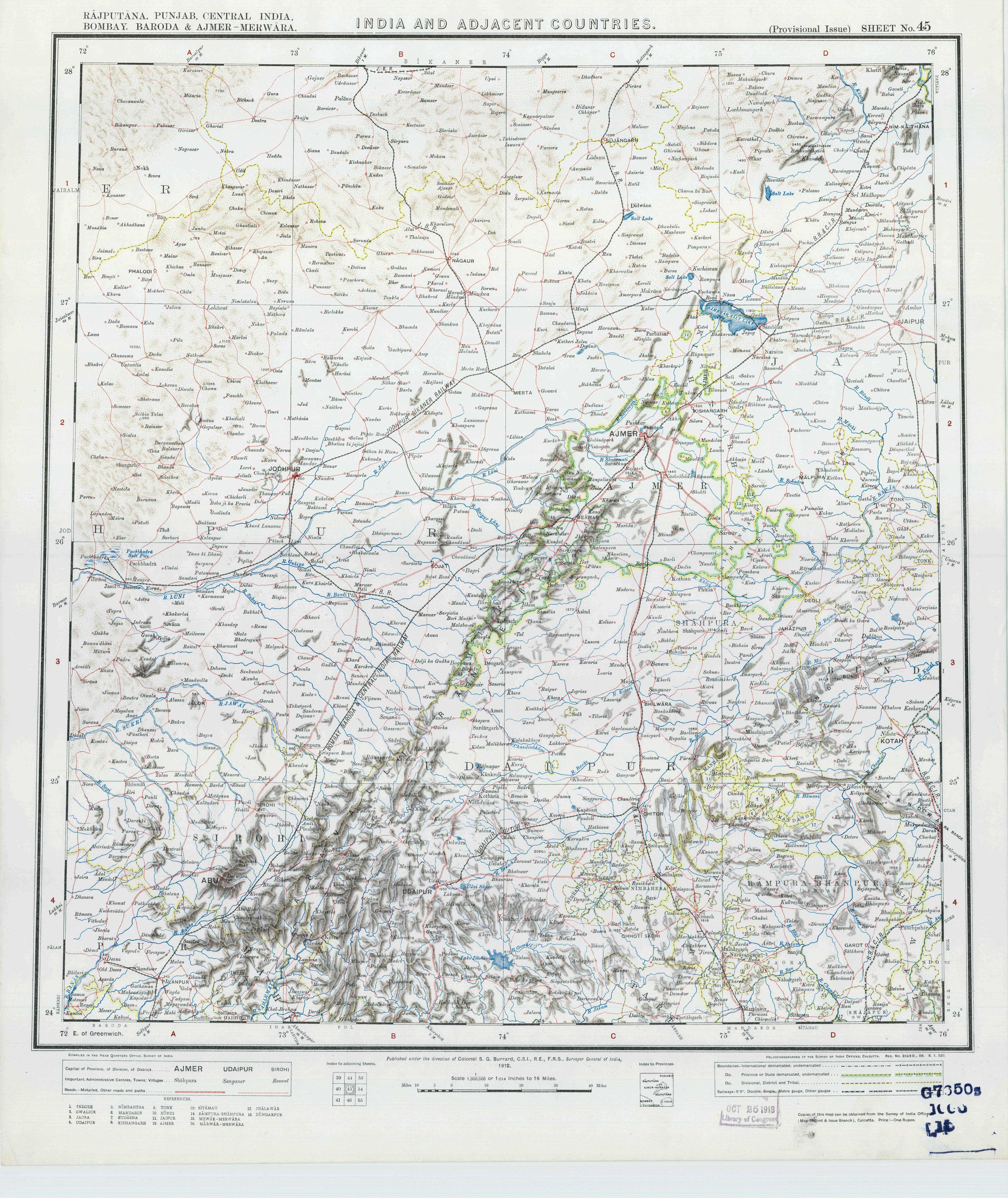
The Church Missionary Society (CMS) began mission work among the tribal population of the Hilly Tracts (Thompson has an expansive definition of 'Hilly Tracts'; see image below) of Rajputana in 1880.

Thompson, C.S., Rudiments of the Bhili Language, United Printing Press, Ahmedabad, 1895, p.II. Link.
A 1890 letter from Rev CS Thompson outlines the beginnings of the Kotra mission. Thompson states that the Maharaja of Idar granted a piece of land for a mission station and Rs 1,500 for erecting a mission building in Kotra (Gujarat). Kotra (Gujarat) is described as a large Bhil village on the other side of the river from Kotra cantonment. Thompson calls a certain Nathabhai, assistant to the political agent of Mahikantha, as a "fellow-labourer." (Thomson himself is stated, in the preface to the article, as "laboring in the Bhil country since 1881"; see pg. 609. He is the author of Rudiments of the Bhili Language.)
Church Missionary Society (1890). The Church missionary review. London: Church Missionary Society, pg. 612. Available at https://catalog.hathitrust.org/Record/000544643
Thompson started missionary work in Kotra in 1891 by erecting a rest house and a school in Kotra (Gujarat). Missionary work continued until 1990.
___, Battling and Building amongst the Bhils, Church Missionary Society, London, 1914, p. 64. (Link)
In August 1892, the Revs. CS Thompson and WB Collins appealed for support from fellow evangelists for their work with the Bhils in Kotra. They described the need as critical because "an Arya Samajist is trying his uttermost to undo all that we have done among these hillmen and because Bhagatism is fast taking its hold on the Bhils."
At the time, the authors reported evangelists' stations in Kherwara, Lusaria, Bilaria, and Kotra (Kherwara described as the "central station").
Church Missionary Society (1892). The Church missionary intelligencer. London: Church
Missionary Society, pg. 582. Available at https://catalog.hathitrust.org/Record/100188881
The station opened by Thompson is said to have been closed in 1900 "after the great famine". "The disused school and bungalow were dismantled and the materials sold."
___, Battling and Building amongst the Bhils, Church Missionary Society, London, 1914, p. 64. (Link)
Details of Thompson's death from cholera are here.
Scott, J (1904), In famine land; observations and experiences in India during the great drought of 1899-1900, New York and London, p. 86. Link
It is reported that around 1911, Helen Bull arrived at the Bhil Mission and it appears she was able to reopen the Kotra station.
Church Missionary Society. (1916). The Church missionary review. London: Church Missionary Society, p. 115. Link.
Bull's station was in the Kotra on the Rajasthan side of Pamri River. A bungalow in the MBK cantonment that fell vacant was sold to the missionaries.
___, Battling and Building amongst the Bhils, Church Missionary Society, London, 1914, p. 65. (Link)
Bhagatism
Rev. CS Thompson derisively calls Bhagatism the "apeing of Brahminism among the Bhils."
Church Missionary Society (1890). The Church missionary review. London: Church Missionary Society, pg. 610. Available at https://catalog.hathitrust.org/Record/000544643
Kaalapani
Among government employees from elsewhere, Kotra is known as 'kaalapani'. The expression was used during the colonial period to refer to the cellular jail in Andaman and Nicobar Islands (India). In a similar way, Kotra served as the “punishment posting” Block for government officials in Rajasthan.
Sarbeshwar Sahoo, Thesis, The multiple faces of civil society: Development and democratization in Rajasthan, India, National University of Singapore, 2009, p.10. (Link)
A Study of Pai
Joshi, J.K., Social Structure & Cultural Change in a Bhil Village, New Heights, New Delhi, undated. Link.
History before Tod
"Very little is known about the early Bhils who inhabited Rajasthan."
Vyas, N. (1978). Rajasthan Bhils: A Contemporary View. In Rajasthan Bhils (p. 1). Udaipur: Manikyalal Verma Tribal Research & Training Institute. Retrieved from https://ia801500.us.archive.org/11/items/in.ernet.dli.2015.117493/2015.117493.Rajasthan-Bhils.pdf.
Settlements
The Bhils never live in villages; teir huts are always separate and scattered all over a valley
General Report on the Operations of the Survey of India, Office of the Superintendent of Government Printing, Calcutta, 1882, Appendix 'Extracts from The Narrative Reports of the Executive Officers', p 12 . Link.
Witch Swinging
An account from 1871.
In 1906, the Kotra bhumat was reported to have a population of 17,641, including 903 persons classified as "urban" (presumably living in Kotra cantonment?).
Erskine, Keith David, 1863-1914, and C. C. (Charles Cuningham) Watson. Rajputana Gazetteers. Ajmer: Scottish Mission Industries, 19041909, p 14. Available at https://catalog.hathitrust.org/Record/012155477/Home.
In 1922, the population of Kotra cantonment was reported to be 857.
India Census Commissioner (1922). Census of India, 1921. Calcutta, p.4. Link.
By 1941, administrative reforms had taken place in Mewar State and Kherwara was organized as a district, of which the thikana of Juda was a sub-division. Presumably, some or all of present-day Kotra lay in the Juda thikana. The population of Juda in 1941 was 27,433.
Dashora, Yamunalal (1942). Mewar in 1941 or A Summary of Census Statistics. Alwar: R.C. Sharma.
Language
"There are a considerable number of words in common use among the Gujaratis and Bhils which are not found in any dictionaries. The question is: Did the Bhils borrow any or all of these words from the Gujaratis, or did the Gujaratis borrow them from the Bhils, or did the Gujaratis and Bhils each add special words of their own to the common vocabulary?"
Thompson, C.S., Rudiments of the Bhili Language, United Printing Press, Ahmedabad, 1895, p.II. Link.
Sharma states that "the dialect...that Grierson has classed as Bhili is Vagadi."
Sharma, G.N. (1960). Social Life in Medieval Rajasthan [1500-1800 A.D.]. Agra: Lakshmi Narayan Agarwal.
However, GS Ojha reports that whereas Mewari is the primary language of the Mewar region, the language spoken in the southern and western parts of Mewar (which includes Kotra) is Vagdi. He describes Vagdi as being related to Gujarati.
Gaurishankar Hirachand Ojha, Udaipur Rajya ka Itihas, Vol 1, Rajasthan Granthaghar, Jodhpur, 1999, p 14. (Link)
As per the 2001 Census of India, 90% of the population of Kotra tehsil speaks Mewari.
Census of India, Table C-16: Population by Mother Tongue, 2001. Available at http://www.censusindia.gov.in/DigitalLibrary/MFTableSeries.aspx
About Bhils
"Although possessing only bows and arrows as their national weapons of warfare, .[the Bhils] have never been entirely conquered. As a people, they have no national aspirations, and, so long as they are left alone, are indifferent to who their rulers may be."
"The Bhils are quite a distinct race from any other Indian tribe, yet few among the latter have higher pretensions to antiquity." (quoting Malcolm's Centrap India p. 517)
Thompson, C. S. (1895). Rudiments of the Bhili language ... Ahmedabad [India]: United Printing Press, pg x. Available at https://catalog.hathitrust.org/Record/007930198
"The space west of Oodipur to the Sirohi frontier is inhabited by communities of the aboriginal races, living in a state of primeval and almost savage independence, owing no paramount power, paying no tribute, but with all the simplicity of republics; their leaders, with the title of Rawut, being hereditary."
Geography of Rajasthan or Rajputana, p. 11. Available at https://catalog.hathitrust.org/Record/012456805
"The Bheel tribes are numerous, and it is much regretted that so little is known respecting them." "The writers of works on Rajputana seen never to realize the interest connected with the individual tribes, and contend themselves with mere generalities and compendious statements."
Sherring, M., The Tribes and Castes of Rajasthan, Cosmo Publications, New Delhi, 1975 (first published 1881), p. 82. Link.
Thushara Hewage, a visiting scholar at Seva Mandir, did an excellent study of the politics of tribal identity in Kotra, in Jura (Juda) panchayat in particular in 1999-00. A bad-quality PDF is at this [permalink]. The report was posted in its entirety on the Jagruk Yuva Sangathan blog (without credits to the author, unfortunately) and is available here.
The paper is a classic. It makes great reading today and will be a useful historic document in the future.
Christian evangelism
The Church Missionary Society (CMS) began mission work among the tribal population of the Hilly Tracts (Thompson has an expansive definition of 'Hilly Tracts'; see image below) of Rajputana in 1880.

Thompson, C.S., Rudiments of the Bhili Language, United Printing Press, Ahmedabad, 1895, p.II. Link.
A 1890 letter from Rev CS Thompson outlines the beginnings of the Kotra mission. Thompson states that the Maharaja of Idar granted a piece of land for a mission station and Rs 1,500 for erecting a mission building in Kotra (Gujarat). Kotra (Gujarat) is described as a large Bhil village on the other side of the river from Kotra cantonment. Thompson calls a certain Nathabhai, assistant to the political agent of Mahikantha, as a "fellow-labourer." (Thomson himself is stated, in the preface to the article, as "laboring in the Bhil country since 1881"; see pg. 609. He is the author of Rudiments of the Bhili Language.)
Church Missionary Society (1890). The Church missionary review. London: Church Missionary Society, pg. 612. Available at https://catalog.hathitrust.org/Record/000544643
Thompson started missionary work in Kotra in 1891 by erecting a rest house and a school in Kotra (Gujarat). Missionary work continued until 1990.
___, Battling and Building amongst the Bhils, Church Missionary Society, London, 1914, p. 64. (Link)
In August 1892, the Revs. CS Thompson and WB Collins appealed for support from fellow evangelists for their work with the Bhils in Kotra. They described the need as critical because "an Arya Samajist is trying his uttermost to undo all that we have done among these hillmen and because Bhagatism is fast taking its hold on the Bhils."
At the time, the authors reported evangelists' stations in Kherwara, Lusaria, Bilaria, and Kotra (Kherwara described as the "central station").
Church Missionary Society (1892). The Church missionary intelligencer. London: Church
Missionary Society, pg. 582. Available at https://catalog.hathitrust.org/Record/100188881
The station opened by Thompson is said to have been closed in 1900 "after the great famine". "The disused school and bungalow were dismantled and the materials sold."
___, Battling and Building amongst the Bhils, Church Missionary Society, London, 1914, p. 64. (Link)
Details of Thompson's death from cholera are here.
Scott, J (1904), In famine land; observations and experiences in India during the great drought of 1899-1900, New York and London, p. 86. Link
It is reported that around 1911, Helen Bull arrived at the Bhil Mission and it appears she was able to reopen the Kotra station.
Church Missionary Society. (1916). The Church missionary review. London: Church Missionary Society, p. 115. Link.
Bull's station was in the Kotra on the Rajasthan side of Pamri River. A bungalow in the MBK cantonment that fell vacant was sold to the missionaries.
___, Battling and Building amongst the Bhils, Church Missionary Society, London, 1914, p. 65. (Link)
Bhagatism
Rev. CS Thompson derisively calls Bhagatism the "apeing of Brahminism among the Bhils."
Church Missionary Society (1890). The Church missionary review. London: Church Missionary Society, pg. 610. Available at https://catalog.hathitrust.org/Record/000544643
Kaalapani
Among government employees from elsewhere, Kotra is known as 'kaalapani'. The expression was used during the colonial period to refer to the cellular jail in Andaman and Nicobar Islands (India). In a similar way, Kotra served as the “punishment posting” Block for government officials in Rajasthan.
Sarbeshwar Sahoo, Thesis, The multiple faces of civil society: Development and democratization in Rajasthan, India, National University of Singapore, 2009, p.10. (Link)
A Study of Pai
Joshi, J.K., Social Structure & Cultural Change in a Bhil Village, New Heights, New Delhi, undated. Link.
History before Tod
"Very little is known about the early Bhils who inhabited Rajasthan."
Vyas, N. (1978). Rajasthan Bhils: A Contemporary View. In Rajasthan Bhils (p. 1). Udaipur: Manikyalal Verma Tribal Research & Training Institute. Retrieved from https://ia801500.us.archive.org/11/items/in.ernet.dli.2015.117493/2015.117493.Rajasthan-Bhils.pdf.
Settlements
The Bhils never live in villages; teir huts are always separate and scattered all over a valley
General Report on the Operations of the Survey of India, Office of the Superintendent of Government Printing, Calcutta, 1882, Appendix 'Extracts from The Narrative Reports of the Executive Officers', p 12 . Link.
Witch Swinging
An account from 1871.
Sunday, November 1, 2009
Random references to Kotra
1. Pertaining to Kotra's administration and the Mewar Bhil Corps stationed there
From the Imperial Gazeteer of India: provincial series, Volume 23, pg 138 (Link):
There is a good sized section on missionary efforts in Kotra in the late 1800 and early 1900 in a book Battling And Building Among the Bhils preserved in electronic format by the University of Toronto library(link).
From The Cyclopaedia Of India And Of Eastern And Southern Asia, Commercial, Industrial, And Scientific; Produces Of The Mineral, Vegetable, And Animal Kingdoms, Useful Arts And Manufactures, Volume 4 by Edward Green Balfour, p 283 (link):
1912 topo map from University of Texas library.
5. About officer stationed in Kotra and his hunting
"Major Hutton Dawson, of Kotra, has a pair of samber horns the measurements of which are near the published record; the animal was shot in the low hills near Kotra."
Adams, A. (1899). The western Rajputana states: a medico-topographical and general account of Marwar, Sirohi, Jaisalmir. London. p. 166. Available at https://catalog.hathitrust.org/Record/006574015
From the Imperial Gazeteer of India: provincial series, Volume 23, pg 138 (Link):
Kotra (ed - the village, not the tehsil) is a cantonment in the south-west of the State of Udaipur, Rajputana, situated in 24 deg 22 min N and 73 deg 11 min E., about 38 miles south-west of Udaipur city, and 34 miles south-east of the Rohera station on the Rajputana-Malwa Railway. A detachment (two companies) of the Mewar Bhil Corps is quartered here, and the officer commanding these is Assistant to the Political Suprintendent of the Hilly Tracts. The Kotra district or bhumat consists of 242 villages, with 16,738 inhabitants, more than two-thirds of whom are Bhils. These villages are owned by the three Girasia chiefs of Jura, Oghna, and Panarwa, who pay a small tribute or quit-rent to the Mewar Durbar.2. Missionary work in Kotra
There is a good sized section on missionary efforts in Kotra in the late 1800 and early 1900 in a book Battling And Building Among the Bhils preserved in electronic format by the University of Toronto library(link).
In 1891 Mr. Thompson, after several previous visits, opened work at a village called Kotra, situated about fifty miles from Kherwara, which offered many facilities for reaching a large tract of hitherto unevangelized country. Kotra comprises two independent villages, one a small cantonment of the Mewar Bhil Corps, which lies on the right bank of the Pamri in Rajputana, and the other a simple Bhil village in Gujarat on the east of the river. It was in the latter that Mr, Thompson erected a rest house and a school, and the Gospel message was proclaimed there until 1900.3.On the lack of Mewar's control on Kotra
From The Cyclopaedia Of India And Of Eastern And Southern Asia, Commercial, Industrial, And Scientific; Produces Of The Mineral, Vegetable, And Animal Kingdoms, Useful Arts And Manufactures, Volume 4 by Edward Green Balfour, p 283 (link):
The hill districts of Oudeypore (ed - Udaipur) to the south and south-west (ed - i.e., Kherwara and Kotra) are inhabited by the wild and turbulent tribes of the Bheel and Grassia (ed - Garasia) under Rajpoot chiefs owing a nominal allegiance to Oudeypore, holding the right of property in the land over which the maharanas have no power, and levying black mail on neighboring villages and a tax on the passage of goods and travellers....accordingly it was proposed in 1838 to raise a Bheel corps to be stationed in these districts.4.On the lack of Mewar's control on Kotra
1912 topo map from University of Texas library.
5. About officer stationed in Kotra and his hunting
"Major Hutton Dawson, of Kotra, has a pair of samber horns the measurements of which are near the published record; the animal was shot in the low hills near Kotra."
Adams, A. (1899). The western Rajputana states: a medico-topographical and general account of Marwar, Sirohi, Jaisalmir. London. p. 166. Available at https://catalog.hathitrust.org/Record/006574015
Geography
1. Report on Wakal River
One important river of Kotra tehsil is Wakal discharges into the Sabarmati a few kilometers downstream of Kotra village. There is a significant study of the Wakal River watershed done by World Vision, a non-profit agency. The report can be found here [permalink].
2. Notes from 1880-81 Survey of India
This report cites that a few observations were made in the Kotra area to form the "basis of a large scale survey of the Cantonment of Kotra." This gives the impression that the town of Kotra was surveyed at the time.
During the survey, the survey party has to employ "considerable tact and judgment." In one instance, the surveyor had to move his camp without delay when the "attitude of the Bhils became somewhat threatening," returning when the situation had calmed down. In another instance, a survey party was surrounded and a surveyor was "hustled off into the center of the pal (village) by a number of armed men; later released at the intervention of women.
General Report on the Operations of the Survey of India, Office of the Superintendent of Government Printing, Calcutta, 1882, p 11. Link.
Report on survey of the Kotra area by Major C. Strahan, in charge of No. 1 Topographical Party:
The large ranges of hill run, as a rule, nearly North and South. The scenery is decidedly fine - the finest I have see in India, away from the Himalayas; some of the gorges, particularly the three by which the Wakli (Wakal River) flows through three large ranges, are very striking. The finest of all is that between Alsigarh and Gorana, known as the Wankli Nal. I was also particularly struck by the immense size and great age of many of the Banian trees in the valleys.
The rivers flow through [the area] are the Wakal, the Sai (Sei) and the Sabamatti (Sabarmati). They all join to form the Sabamatti, which flows by Ahmedabad; they are mere mountain torrents, flowing down broad, stony or rocky beds, with patches of sand as they get farther south, until at last the bed of the Sabamatti becomes principally sand.
General Report on the Operations of the Survey of India, Office of the Superintendent of Government Printing, Calcutta, 1882, Appendix 'Extracts from The Narrative Reports of the Executive Officers', p 12 . Link.
3. Alps
"Let us take a section of it, from the capital, Oodipur, the line passing through Oguna, Panurwa, and Meerpur, to the western descent near Sirohi, a space of nearly sixty miles in a direct line, where "hills o'er hills and alps on alps arise," from the ascent at Oodipur to the descent to Marwar."
Geography of Rajasthan or Rajputana, p. 11. Available at https://catalog.hathitrust.org/Record/012456805
4. Historical Rainfall
1891-1922:
https://catalog.hathitrust.org/Record/012504759
1875-1890:
https://catalog.hathitrust.org/Record/007957916
5. Drought of 1899-90
"In 1888, the rain ceased in August and relief works in the Hill Tracts gave employment to many starving Bhils. In 1899, the rainfall was very scanty and little or no rainfall after June. Crops failed and fodder was exceedingly scarce. Relief works and poor houses were started in September. In the Hilly Tracts, the famine was very acute and the situation had become desperate by November 1899."
Unknown book (Link)
The Rev. C.S. Thompson wrote from Kotra on January 25, 1900: Major and Mrs. Dawson of the Bhil Corps in Kotra have turned the school house into an asylum for children, who are fed twice daily. For the sick, some of the buildings are used as hospitals. For those able to work, Major Dawson has started relief works. Thompson died shortly thereafter, probably by contracting cholera (see p. 469 of cited document).
Church Missionary Society (1900). The Church missionary intelligencer. London: Church Missionary Society, pg. 294. Available at https://catalog.hathitrust.org/Record/100188881
"The famine among the Bhils is becoming more and more acute. Corpses and skeletons are lying about in all directions. The mortality has been very great among the little children and old people. The starving crowds who come to our relief centres seem to have lost every bit of feeling, except the intense craving for food."
Church Missionary Society (1900). The Church missionary intelligencer. London: Church Missionary Society, pg. 455. Available at https://catalog.hathitrust.org/Record/100188881
A book about the 1899-90 Famine
Scott, J (1904). In Famine Land: Observations and Experiences in India During the Great Drought of 1899-90. New York and London: Harper & Brothers Publishers. Link.
6. Note about principal villages from 1880-81
The principal villages we met with (towns there were none) were Jura, Ogna, Manpur, Bikarmi (Bikarni), and Mairpur (Merpur) in Meywar (Mewar), and Rohera (Rohida) and Pindwara in Sirohi. the first three (Jura, Ogna, Manpur) are the residences of petty chiefs calling themselves Rajputs, but in reality only Grasias, i.e., the descendants of Rajput Chiefs and Bhil wives; they consist of a few mud huts with perhaps one or two bania's shops.
General Report on the Operations of the Survey of India, Office of the Superintendent of Government Printing, Calcutta, 1882, Appendix 'Extracts from The Narrative Reports of the Executive Officers', p 12 . Link.
7. Bhomat
"In the minds of its inhabitants, the former State of Udaipur was considered to consist of three main parts: the plaint of the north and east, known as Mewar; the foothills called Magra, and the highlands of the south and west, the Bhomat."
Carstairs, G. Morris (1955), Bhil Villages of Western Udaipur: A Study in Resistance to Social Change, India's Villages. Bombay: Asia Publishing House. p. 68. Link.
Subscribe to:
Posts (Atom)